Mesmerizing.
Never seen wind being “created” in a shape quite like this before.
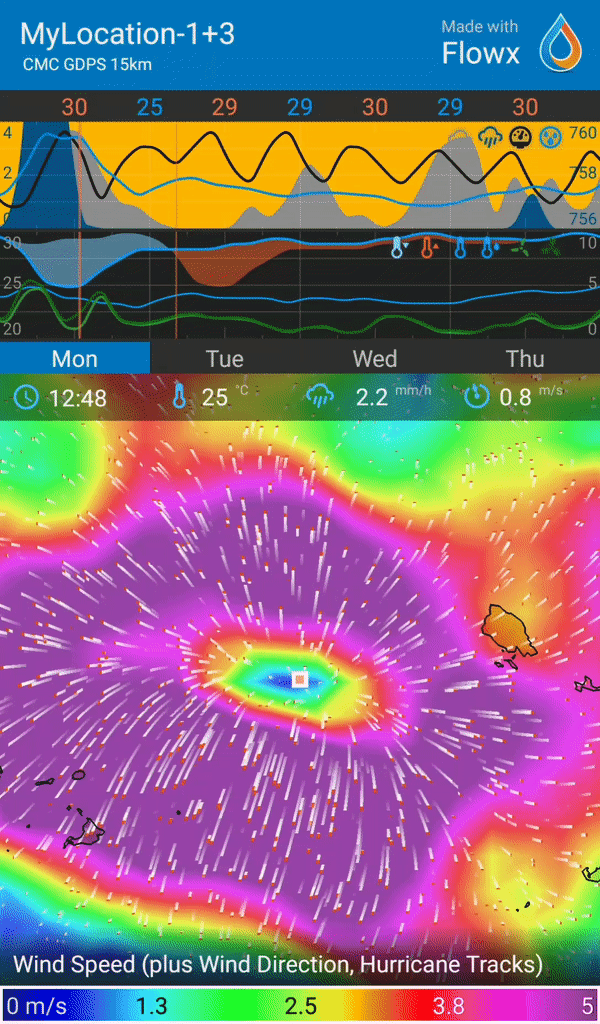
It is just south of the hurricane track, that is Noth of Australia right now.
Mesmerizing.
Never seen wind being “created” in a shape quite like this before.
It is just south of the hurricane track, that is Noth of Australia right now.
Same area, but a bit more zoomed out and with the opacity of the wind data style turned down, so that you can see the hurricane track above.
So that you can find it if you want to see it in your own device.
(I used the “gentle breeze” setting for the wind color.)
I think this is caused by a rain downpour. If you turn on precipitation you’ll see rain associated with this. My assumption is the rain falling will drag air down with it and when it hits the ground, it has to go somewhere, and that is outwards. This is possibly why you get wind gusts before rain arrives.
You see this often with high resolution data like HRRR or NAM 3km. It’s rare to see it with GFS, GDPS and ICON.
We need someone with experience with weather modelling to confirm if it is.
Sounds reasonable. Yes it would be interesting to hear a confirmation on that.
Sadly I don’t have anything smaller than 7.5 km resolution in my area.
By the way, as you can see above, in the video it says “GMC GDPS 15 km” , but in the still-image it soes not say the name of the forecast model.
Maybe is should?
And both says “My Location…” rather than “Pin”, despite that I had panned on the map from “My Location…”
