Yesterday I was on a long bike ride on a peninsula near Traverse City, MI with my wife and 2 year old son. A storm was approaching. I’ve used Flowx to dodge storms before - I love Flowx. Well this time I said, “let’s head north towards the tip of the peninsula and we can dodge the storm.” AKA let’s ride straight into a dead end alley and get killed by this weather.
Luckily for me some people stopped us and said, ‘Hey a storm is coming. Wanna take refuge on our porch?’
I almost told them, ‘no, I have Flowx so we’re fine.’
Thank god I didn’t. We rested safely on their porch while the NOAA HRRR forecast was proven very very wrong and the entire area got smashed by a huge thunderstorm.
It’s storming again here this morning and I’m having massive questions about my understanding of the radar systems in Flowx and I need the forum’s help!
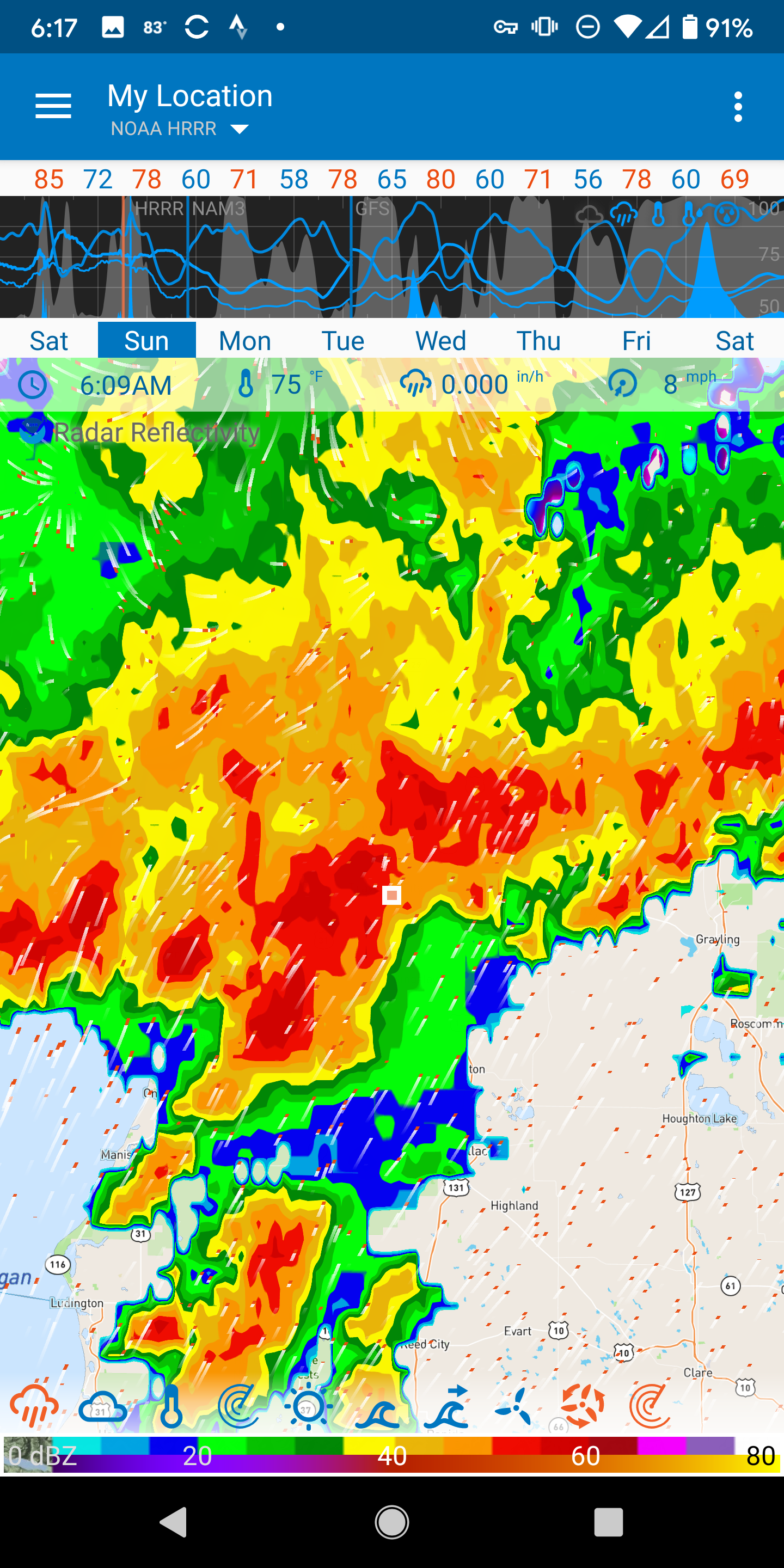
Why is the NOAA HRRR composite radar so different than Rainviewer? It’s storming like crazy right here and now - 6:09am - I’m looking out the window. First screenshot: composite. 2nd screenshot: Rainviewer. Notice they are both selected for the last available data point, not a forecast (double clicked the time to get that) (right?).
Shouldn’t the composite radar include the base reflectivity and thus account for the rain that falling at ground level?
Perhaps the double clicking of the time in Flowx didn’t actually pull up the last known data in the composite and therefore I am looking at a forecast?
Duane, perhaps the icons for radar composite and Rainviewer data on the bottom of the map should be made to look different. Yesterday my icons were next to each other and I really wasn’t aware of the big difference between the two.
There is no radar forecast for Rainviewer data right? So as I’m ‘thumbing’ through time of Flowx and I continue past the current moment, do I have to manually switch my radar from Rainviewer to composite? I can see that the ‘precipitation’ data can be loaded behind the radar (Rainviewer or composite), but composite (NOAA with forecast) can’t be loaded behind Rainviewer. Or perhaps it could be loaded side by side? Rainviewer up to the current moment then an auto switch to composite?
Is there something I’m missing here? Is composite not supposed to be the best radar for ground level precipitation and tracking of storms like this overall?
Last thing: NOAA was supposed to release a major update to their radar recently and it was delayed, right? And that update was going to include more frequent data updates, right?
I’m shaken up by my inaccuracies yesterday. Thank god for those people. I would’ve led my family into serious trouble so I need to educate myself and get my feet back under me. Thanks Flowx community!! Looking forward to your help.
Damn! Can’t post more than 1 screenshot because I’m a new forum user. Will only post the NOAA composite screenshot for now.
…and after reflecting perhaps I forgot the most important rule that Duane says: Flowx is for general weather trends, not hyperlocal short term forecasts. Forgot about that yesterday…
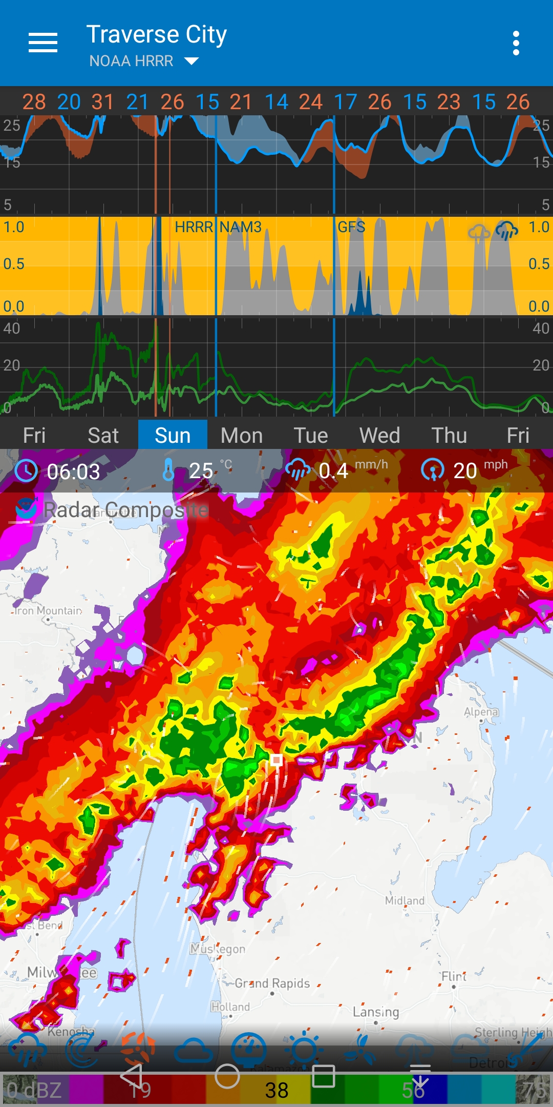
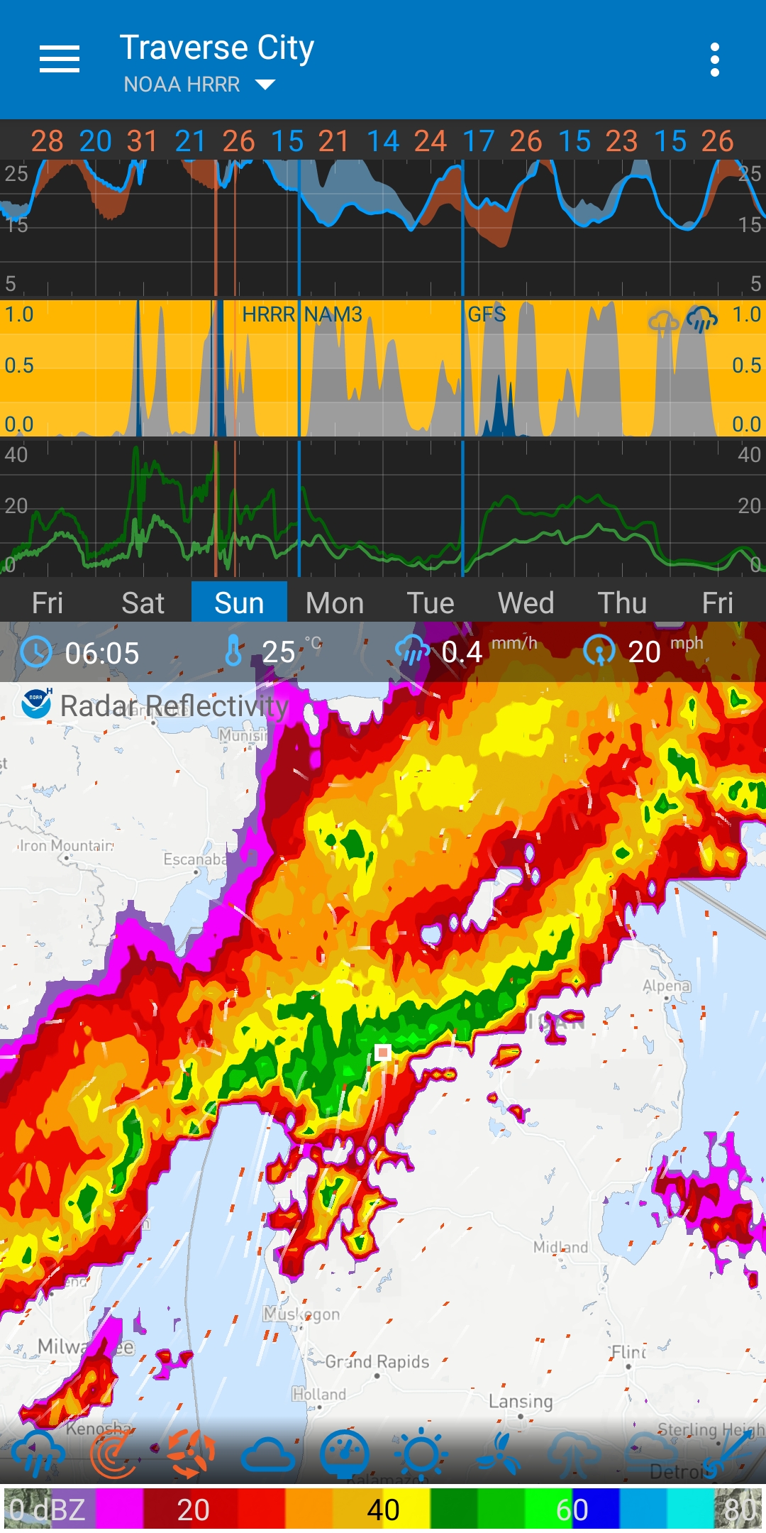
When the storm was happening the radar looked very different than it does right now when I pull up the radar data from this morning.
Obviously radar is data, so once the data comes in that’s when it’s most accurate. But in the moment, when I double click on the time, I thought I was receiving the most up-to-date radar info, therefore it shouldn’t be different retrospectively like it is in this case. Most specifically speaking now about the NOAA composite, not RainViewer data
@Bri1231 radar is not right now right this minute the Info from the Different models from multiple sources gets analyzed then averaged then the Info is released to the public then apps like Flowx download it so there is a delay except when they “predict” what will happen.
@Bri1231 Radar can’t tell you what will reach the ground as they are on mountain tops. you can have a return on Radar and Absolutely nothing hitting the ground that’s why there are Programs like Skywarn and CoCoRaHS weather Spotter Programs.
Ok, but what about RainViewer vs the NOAA composite aspect in all of this. RainViewer updates every 15min from what I understand and it seems to be quite accurate in terms of demonstrating where rain is actually falling and where the strong cells of a thunderstorm are. Shouldn’t NOAA composite do the same? Why doesn’t it? Or why didn’t it in this case? I haven’t looked into this, but I bet RainViewer gets some/most of its data from the radar that NOAA uses/produces.
@Bri1231 yesterday RainViewer showed rain for my location NOAA showed it just missing my location we had zero rain but a bad dust storm which can show a return on Radar I don’t know why at times things might or might not show up. sorry I don’t have a more educated and scientific answer for you.
No problem! I appreciate your input regardless. I know Duane will have an answer. But of course this question is not urgent and I’m sure he is enjoying his Sunday, as he should be! I will still be an avid Flowx user regardless, just want to fine tune my knowledge and use of the various technologies.
@Bri1231 I feel ya I’m a weather geek absolutely love the weather and trying to figure out why/how forcasters determine what might happen and when and why some say A others say B and the weather chooses option C
RainViewer is real MEASURED data so it’s only history up to about 10 minutes prior to now. Radar are slices through the atmosphere.
HRRR Radar is PREDICTED forward from measured radar. The 1km and 4km radar is similar to a measured radar slice. Composite is merged many slices together. Don’t quote me on this. This is my understanding and can be wrong.
Understanding weather - Shux man - I would not go out in that. That was a bad decision.
high pressure systems are stable and easy to predict.
low pressure systems are unstable and hard to predict.
storms fronts are very hard to predict and can change quickly
tornadoes are the extreme…
If you see the strong storm front, expect it to hit but how it hits can change. This is the big picture thing. When you have a lot of water falling it displaces air and you get massive wind gusts. Where water falls will affect the surrounding area, wind in the terrain and where more rain will fall. This is a complex system. Hard to predict. Treat storm weather with respect even if you have a good understanding of weather. Storm chasers treat weather with respect.
A similar example of predictions are waves on a bay. On a nice calm day (high pressure) with a nice swell, the small waves are easy to predict. In a storm (low pressure), you can see the waves coming, but it hard to predict where they will break and how waves and wind will affect other waves.
When viewing weather predictions, think of it in probabilities, i.e., rain plus or minus something. “something” in stable high pressure systems is small. “something” in unstable low pressure systems is big. Essentially blur your vision.
To understand this more. Add “hurricane tracks” and look at the two systems in the pacific and read the “Hurricane tracks” help. This is the variation (plus or minus) for these storms. These are relatively tight tracks. When the storm is in the Caribbean, the tracks can vary more because there are more features that can affect the storm path. Just from looking at the map, it looks like your region has many features that can affect a local storm.
I’ll throw in my disclaimer. I am not a meteorologist so don’t quote me on the weather stuff. This is my understanding from snippets Ive seen over the years developing Flowx. I took no formal course on weather. But I do have a background in physics and numerical methods and modelling so I understand the abilities and limitations of simulations.
Just as an exercise. Zoom out so you can see Detroit and Toledo, turn on precipitation, set the time to when the storm hit, then change between the different data sources. Why are they so different? The main difference is the resolution and time steps. But if you switch between HRDPS and NAM (conus) (and HRRR) which has very similar resolutions and time steps - they are still very different. This is the limitation of modelling the weather.
Thanks Duane. But what about the difference in the appearance of the composite HRRR radar at 6:09am while it was happening (my screenshot) vs the same composite radar at 6:09am when viewing retrospectively? (as if you’re pulling it up now)…in regards to the difference between those. And that is taking into account the fact that I had double clicked the time (while viewing real time), so I should’ve been pulling up the most recent recorded data, right?
The main difference is composite reflectivity shows the highest dBZ (strongest reflected energy) at all elevation scans, not just the reflected energy at a single elevation scan. … Base reflectivity only shows reflected energy at a single elevation scan of the radar.