Hello,
We have used FLOWX for a couple years. Today April 20 was the first time it completely missed a severe weather pattern coming off the Gulf going East including tornado, hail etc. Anyone know why?
Voyageur
Hello,
We have used FLOWX for a couple years. Today April 20 was the first time it completely missed a severe weather pattern coming off the Gulf going East including tornado, hail etc. Anyone know why?
Voyageur
@chk Welcome to the Forum and Thank You for using Flowx
@chk just curious did you look at multiple models like GFS, CMC, HRR?
Yes I thought I did. I had Bronze then switched to Gold to see if I could see the storms but could not
@chk interesting I wasn’t able to replicate some models showed less of a storm others showed heavy storm.
Hi @chk,
It’s difficult to answer your question without more information.
But just to be clear Flowx did not miss this severe pattern, instead “why did GFS missed the severe weather?” or “why did HRRR missed the severe weather?”. There are 7+ models that cover that region. It is important to make this distinction.
Weather models do not predict hail or tornadoes, instead these are inferred as a probability from other information. They predict the disparity of temperature (CAPE and Lifted Index) in the atmosphere that would cause turbulent air and hence extreme weather. You need to be a meteorologist to interpret this data into extreme weather predictions. This is about the right time to make a disclaimer: this is my basic understanding of weather forecasting. I’m not a meteorologist and don’t quote me on this.
Another point to make is that the highest resolution model, HRRR, has a resolution of 3km. A tornado is 50-100m across. There is no way HRRR or any other model can predict a single tornado. Likewise, some rain storms are less than 3km wide, and likewise these models cannot predict individual rain storms.
I’ll make this point again. Flowx does not make weather predictions, in fact, I flatly decline any request to make predictions (like frost). Flowx simply shows the raw data resulting from weather simulations. It is up to you to make your own predictions from this. Flowx is simply the messenger.
The reason I emphasize this point is because people say things like “Flowx is terrible. Wunderground predicted rain, and Flowx didn’t”. These people don’t understand that the data in Flowx, GFS, GDPS, NAM, HRRR is use by Wunderground to make their prediction.
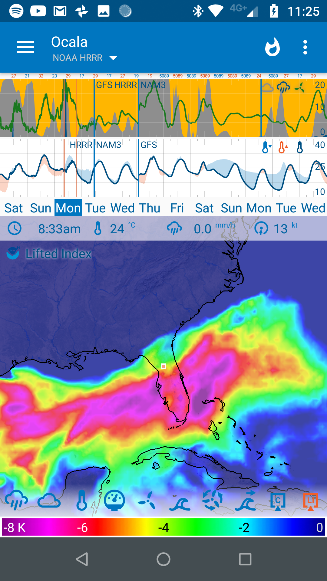
Here you go. A user sent me this the other day:
Lifted Index
If you turn on Lifted Index and set the scales between -7 and 0, there was some very unstable regions over the last day.
Here is some info on CAPE:
Predict Wind on CAPE, Wind Gusts, etc…
I am learning this as we go. BTW, I read a long time ago that Hail is produced in thunder storm clouds by pellets being lifted up and down, rolling around and gaining size until they are too big for the updraft to keep up.
@duane that’s what I was getting severity changed a little per different model but that’s why there are different models 
Really need to add Lifted Index and Cape to the graph so you can compare them across weather models.
@duane interesting idea
Hello and thanks so much for the responses. Duane, I clearly understand and agree that severe weather predictions are not the deliverable here.
The picture of Ocala weather showing the whole system in Florida yesterday did not appear on my FLOWX as of 09:00 yesterday. My Daytona Beach FL location showed a bit of rain early around 08:00 and no rain after that and the large system crossing central FL did not appear. So is it my settings and how to I add Lifted Index and Cape to my app?
@chk to add Lifted Index and CAPE tap the three dots upper right corner select edit data when the window pops up scroll down to storms then select Lifted Index and Cape
Thank you BrianLY! I’ll see how things go now.
Have a safe day!